| Product Name: |
LandUse Analyst |
| Graphically outline suitability zones for each Category over a background map or import the Category zones from Autocad DXF or Arc/Info and ArcView Shape files. |
LandUse Analyst is a multi-category land use evaluation system integrated within the Argus ONE GIS environment. It allows the user to conduct a detailed land use analysis subjected to leveled influencing criteria called Categories and Sub Categories. The user graphically outlines the suitability zones for each Category over a background map or imports the Category zones from Autocad DXF or Arc/Info and ArcView Shape files. Categories are assigned weights and LandUse Analyst automatically calculates the suitability of the land use over the entire evaluated area which is visualized as graduated colors over the map. The system allows the user to view the suitability for each single Category and hence to on-line perform powerful What If analysis.
 |
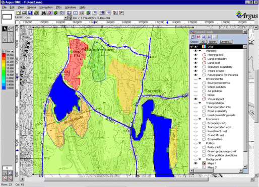
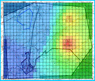
| LandUse Analyst automatically calculates the suitability of the land use over the entire evaluated area which is visualized as graduated colors over the map. In this example, water front areas with moderate topography are assigned a higher grade for a residential housing project. |
 |
| |
|
| Required Argus ONE Modules |
GIS and Grid Modules |
| Developed by: |
g-bina |
|
|
g-bina Ltd. is an independent consulting firm in the areas of environment and infrastructure. g-bina Ltd., is located in Israel. |
|
|
| List Price: |
- Argus ONE GIS and Grid Modules, and the LandUse Analyst PIE - $1800.00
- LandUse Analyst PIE for Argus ONE users who have the GIS and Grid modules - $ 800.00
|
|
LandUse Analyst - Find the Most Suitable Location
|
| The Problem |
Where are the best locations for developing a new residential area?, In which areas will a development site have the least impact on the environment?, Are the selected sites economically feasible?, Where is the most suitable location for a new hospital?, for a new dump site?, Where should a new golf course be developed?
These and similar questions deal with the a quantitative process of finding the best location for developing sites for different purposes. Such a process requires synthesis and analysis of large quantities of information and data. The complexity of finding the answers to such questions results from the fact that very many factors influence the answer. It is a multi-dimensional analysis process. |
| The Answer |
If you find yourself asking such questions while gazing at vast amounts of information, here is your long waited answer: LandUse Analyst |
|
LandUse Analyst is a new Argus ONE Plug-In Extension (PIE) which relies on the unique GIS and CAD capabilities of Argus ONE and enables you to evaluate any criteria influencing the new land use requirements in a graphical, interactive user friendly environment. LandUse Analyst enables you to perform rapid analysis and to immediately visualize the results. Like in a spreadsheet, you change any of the data, and the results and charts automatically update on-screen. You can dynamically change the criteria and factors influencing the solution and adjust them according to customer requirements. |
| |
|
| How Does it Work? |
Using coverages, DXF files, Shape files, or digitizing polygons on-screen each zone in the investigated area is assigned a grade in relation to a certain criteria, say for example land cost. The grades are between 0 to 5, where 0 denotes non-feasible and 5 is denotes most suitable (in the case of land-price 5 will be the land with the lowest cost). The criteria are given weights in the decision, again here 1 denotes a low weight and 5 denotes the maximum weight. Once all criteria have been assigned values, the final calculation automatically assigns each point on the map its weighted grade, as LandUse Analyst multiplies each criteria with its weight and sums all criteria at each point. |
| What if Analysis! |
LandUse Analyst lets you evaluate as many scenarios as you need. Just change the criteria weights and see the result change graphically. It is as easy as said, no pre calculation is required as everything is automatically evaluated online. |
| |
|
| Start Working Now! Use Pre-Defined Templates! |
LandUse Analyst comes with an abundance of pre-defined templates for typical land-use analysis for different purposes. You can use these templates as is, or choose to refine them for your specific site and customer requirements. |
| |
|
| Customize Your Own Templates! |
LandUse Analyst allows you to interactively design new templates defining new criteria and sub-criteria as required. |
| |
Complete an Analysis in Only a Few Steps
|
| |
Using LandUse Analyst you can geographically present the multi-dimensions land-use feasibility in the area under consideration. The analysis is performed in only a few steps, at the end of which the land-use suitability, weighting all criteria, is graphically presented on-screen. |
| |
Defining the investigated domain
|
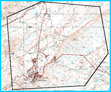
Define The Investigated Domain
Using Argus ONE tools, background maps are imported and the investigated domain is defined using arc and polygons which may be digitized on-screen from the background map or imported from CAD and/or GIS files.
Background maps can be scanned images (raster formats) or CAD/GIS drawings (vector formats)
The domain may be assigned a default resolution which will set the solution grid refinement. |
|
| |
The investigated domain is discretized
|
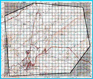
Grid the Domain
The domain is automatically discretized using the Argus ONE automatic grid wizard (the magic wand) or may also be manually discretized.
The refinement of the grid may be easily changed to allow for analyzing the sensitivity of the solution to the grid refinement.
For optimized performance the grid may have different cell sizes at different zones of the investigated area. |
|
| |
Zones are outlined and assigned grades
|
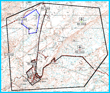
Assign Grades to Zones
For every criteria an sub-criteria zones are marked using on-screen digitizing or by importing coverages and GIS themes .
The zones are assigned grades and criteria's weights may be changed.
Zone definitions may be also copied from one layer to the other to assign different grades to the same zone for different criteria. |
|
| |
LandUse Analyst weighs all
criteria and presents the solution
|
Obtain a Solution
The solution is readily made visible just by showing the grid. Each grid cell is automatically evaluated and assigned a color representing the final grade assigned to it.
Land-use suitability can be evaluated for each of the criteria at a time allowing one to examine the influence of the various criteria on the final solution.
The grid may be refined to test the sensitivity of the solution to the grid refinement or to capture fine details. |
|
